| Code | Water Source Type | Inspecting Agency | Inspection Date | Region | District | Settlement Name | Settlement Distance | Establishing Agency | Establishing Date | Source Name | Latitude | Longitude | Sources Cluster | Water Source Photo | Users | Permanent? | Months Used | Functioning? | Non Function Reason | No of Humans | No of Camels | No of Cattle | No of Shoats | Irrigation Area | Source Protected? | Borehole Depth | Casing Type | Casing Size | Borehole SWL | Borehole Operating Yield | Borehole Operating Hours | Borehole Operating Drawn | Borehole Recovery Time | Dugwell Depth | Dugwell SWL | Dugwell Yield | Dugwell operating hours | Dugwell draw down | Recovery time | Dam depth | Dam length | Dam width | Berkad depth | Berkad length | Berkad width | Spring Cumulative discharge rate | Other depth | Other length | Other width | Other source yield | Reservoir Type | Reservoir Capacity | Pipeline Type | Pipeline Length | HouseHold Connections | Water Point Kiosks | Troughs | Source Emergency? | No of Trucks | Truck Capacity | Pump Type | Pump Model | Pump Capacity | Pump Level | Power Source | Generator Type | Generator Capacity | Solar Type | Solar Capacity | Supply Condition | Supply System Condition Notes | Physical Water Issues | Physical Problem Reason | Temperature | pH | Electrical Conductivity | Total Dissolved Solids | Water Sample Code | Management Type | WSC | WSC Established Date | WSC Male | WSC Female | Watercharged Humans? | Cost Of Water Humans | Watercharged Animals? | Cost Of Water Animals | Last Intervention Agency | Last Intervention Description | Intervention Date | Proposed Intervention Description | Additional Notes | |
|---|---|---|---|---|---|---|---|---|---|---|---|---|---|---|---|---|---|---|---|---|---|---|---|---|---|---|---|---|---|---|---|---|---|---|---|---|---|---|---|---|---|---|---|---|---|---|---|---|---|---|---|---|---|---|---|---|---|---|---|---|---|---|---|---|---|---|---|---|---|---|---|---|---|---|---|---|---|---|---|---|---|---|---|---|---|---|---|---|---|---|---|---|---|
| DWSLTA014 | Dug Well | Somaliland_MoWRD | Oct. 27, 2019 | Sool | Taleex | Carooley | None | Other | 4/5/1970 | Carooley 1 | 8.8561 | 48.1469 | 0 | 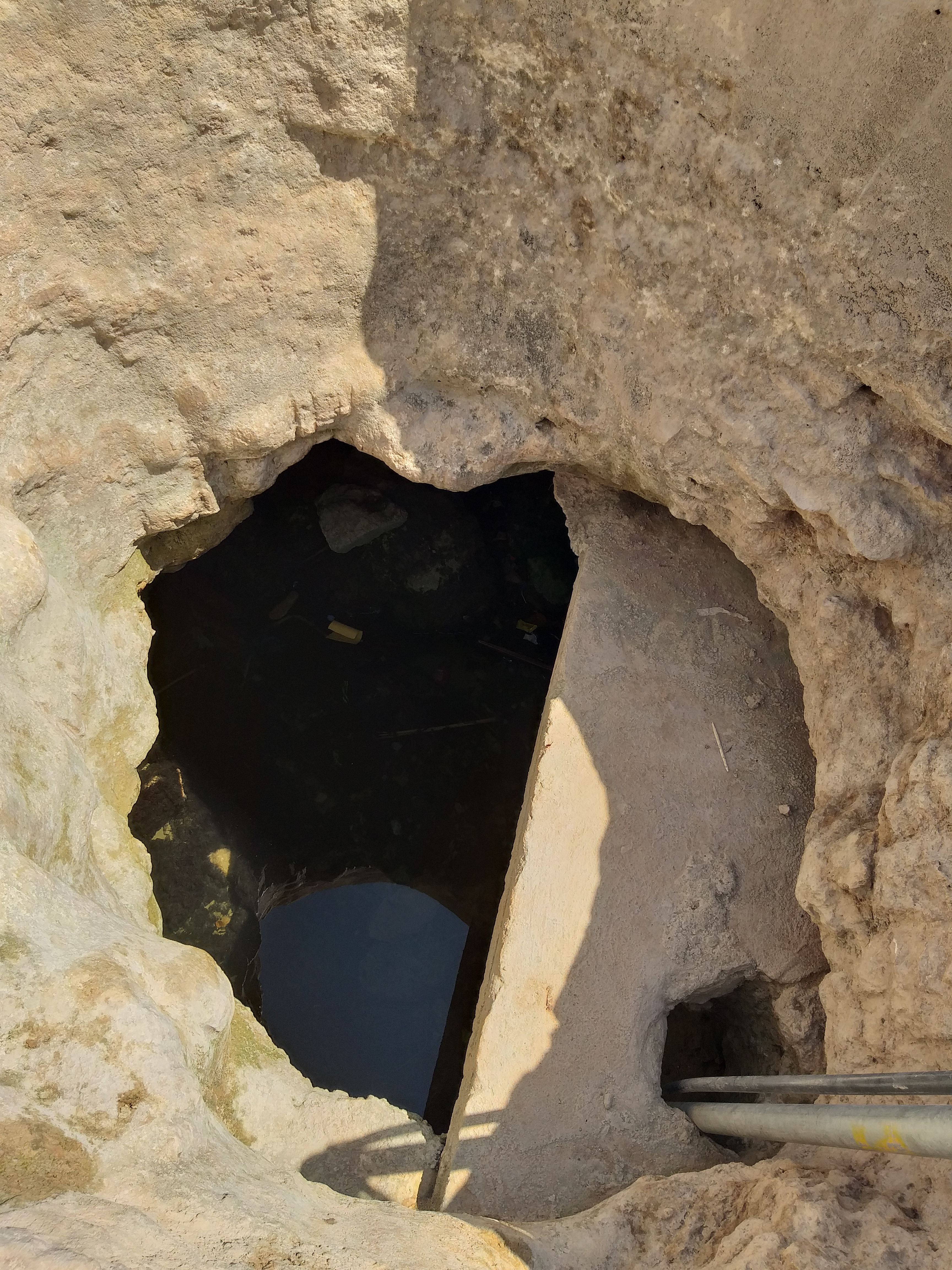 |
None | yes | None | yes | None | 2400 | None | None | None | None | No | None | None | None | None | None | None | None | None | 6.0 | 1.0 | 2.66 | 6.0 | 0.0 | None | None | None | None | None | None | None | None | None | None | None | None | Concrete/Masonry tank | None | Galvanised Steel | Invalid: "data.pipeline_lengthe" | 20 | 6 | 6 | no | None | None | None | Grundfos | 1.1 | 4.0 | Submersible Pump | Perkin | 30.0 | Photovoltaic | 1.5 | None | None | No | None | 37.0 | 8.05 | 5130.0 | 3540.0 | No Document | None | Yes | 10/9/2016 | 5 | 2 | No | None | No | None | None | No intervention | None | Increasing the number of solar panels. Pipe line extantation connecting to MCH and schools. Replacement of pipe connecting the animal troughs. Rehabilitation of elevated water tank | None | |
| Code | Water Source Type | Inspecting Agency | Inspection Date | Region | District | Settlement Name | Settlement Distance | Establishing Agency | Establishing Date | Source Name | Latitude | Longitude | Sources Cluster | Water Source Photo | Users | Permanent? | Months Used | Functioning? | Non Function Reason | No of Humans | No of Camels | No of Cattle | No of Shoats | Irrigation Area | Source Protected? | Borehole Depth | Casing Type | Casing Size | Borehole SWL | Borehole Operating Yield | Borehole Operating Hours | Borehole Operating Drawn | Borehole Recovery Time | Dugwell Depth | Dugwell SWL | Dugwell Yield | Dugwell operating hours | Dugwell draw down | Recovery time | Dam depth | Dam length | Dam width | Berkad depth | Berkad length | Berkad width | Spring Cumulative discharge rate | Other depth | Other length | Other width | Other source yield | Reservoir Type | Reservoir Capacity | Pipeline Type | Pipeline Length | HouseHold Connections | Water Point Kiosks | Troughs | Source Emergency? | No of Trucks | Truck Capacity | Pump Type | Pump Model | Pump Capacity | Pump Level | Power Source | Generator Type | Generator Capacity | Solar Type | Solar Capacity | Supply Condition | Supply System Condition Notes | Physical Water Issues | Physical Problem Reason | Temperature | pH | Electrical Conductivity | Total Dissolved Solids | Water Sample Code | Management Type | WSC | WSC Established Date | WSC Male | WSC Female | Watercharged Humans? | Cost Of Water Humans | Watercharged Animals? | Cost Of Water Animals | Last Intervention Agency | Last Intervention Description | Intervention Date | Proposed Intervention Description | Additional Notes |


